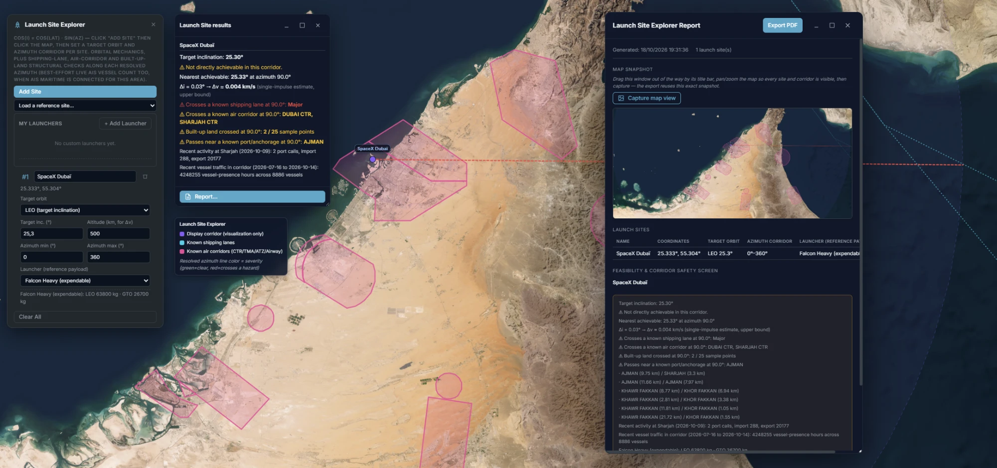
For a candidate launch site and a target orbit, resolves exactly which launch azimuths reach it —
real spherical trigonometry, not a rule of thumb — then screens the resolved corridor against
known shipping lanes, air corridors, built-up land and ports, enriched with recent traffic
density. Every signal drawn on the real site, every result exportable as a branded PDF report.
Exact spherical trigonometry
Feasibility — which azimuths actually reach the target orbit
cos(i) = cos(lat) · sin(Az), solved for both azimuth roots within the site's permitted corridor —
LEO against a target inclination, SSO derived from altitude through first-order J2 nodal
precession, or GEO's near-equatorial case. When nothing in the corridor reaches it directly, the
nearest achievable inclination and its plane-change delta-v penalty are reported instead of a
flat no.
Both roots, not one
A target inclination generally has two azimuth solutions, not one — both resolved and checked
against the site's actual permitted corridor, so a real direct-ascent option is never missed
because only the first root was considered.
A real delta-v, not a flag
Not directly achievable still reports a number: a single-impulse upper-bound estimate for LEO,
or a combined circularization-plus-plane-change burn at GTO apogee for GEO — against a
custom launcher library's own LEO/SSO/GTO payload figures.
Structural safety screen
Does the corridor cross a known hazard — not just a live snapshot
A live AIS vessel count only answers "is a ship there right now." The question that actually
matters for siting is structural: does the resolved corridor cross a known shipping lane or air
corridor at all. Every signal below is drawn on the real site, colour- and style-coded by
severity so adjacent layers never blur together.
Known shipping lanes
Global Major/Middle/Minor shipping-lane center-lines tested against the resolved ray — the
primary maritime signal, with a best-effort live AIS vessel count alongside it as a
secondary, supplementary note.
Air corridors
Live OpenAIP airspace data — CTR, TMA, ATZ and en-route Airway types together, so a site next
to a major airport's own control zone is caught, not just the en-route corridors between
navigation fixes.
Built-up land
The resolved ray sampled every 10 km against ESA WorldCover's own published land-cover
classification — a structural "does this corridor cross built-up land" check, not a census
figure.
Launch Site Explorer · results window, map legend and branded report, all in sync
Planning aid, not certified range-safety clearance. Every structural signal here —
shipping lanes, air corridors, built-up land, port proximity — says so explicitly in both the panel
and the report. It narrows down where to look first; it is not a substitute for a certified range
safety process.
Ports & recent traffic
A local geospatial store, enriched with recent activity
A self-hosted PostGIS store — the NGA World Port Index, Global Fishing Watch's anchorage
database and Marine Regions' territorial-waters boundaries — resolves the nearest port or
anchorage to the corridor, closing the gap a global shipping-lane dataset alone leaves at
port-level approach distances. Two dynamic layers enrich it further, each degrading cleanly
when not configured rather than blocking the rest of the screen. SatView never bundles, sells
or redistributes this third-party data itself — it only provides the means to connect to each
source, on your own credentials where one is required.
IMF PortWatch activity
Recent port calls and import/export volumes for the nearest matched port — a public, keyless
data source, no account or key to configure.
Global Fishing Watch traffic
Recent vessel-presence density — all vessel types, not just fishing — across the site's whole
display corridor, from your own GFW account. A recent-history figure, not a live feed.
Powered by Global
Fishing Watch.
Every result, a report someone else can read
The same branded PDF export as the rest of the platform — a map snapshot, every site's full
feasibility and safety-screen detail, and every shipping lane or nearby port listed individually,
not just the worst case.